Showing 10 items matching school ridge road
-
 Eltham District Historical Society Inc
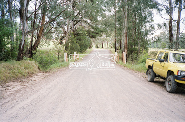
Negative - Photograph, Cottlesbridge-Strathewen Road, Strathewen, c.Nov. 1987
... school ridge road... cottlesbridge-strathewen road culvert infrastructure roads school ridge ...Photos taken during a review of road and bridge/culvert condition by Eltham Shire Council engineers. A number of the trees were badly burnt or destroyed in the Black Saturday bushfire, 7 Feb. 2009 but some remained standing and identifiable as of 2014 (Google Streetview).Roll of 35mm colour negative film, 4 stripsKodak GB 200 5096bridge, chads creek, chads creek road, cottlesbridge-strathewen road, culvert, infrastructure, roads, school ridge road, strathewen -
 Eltham District Historical Society Inc
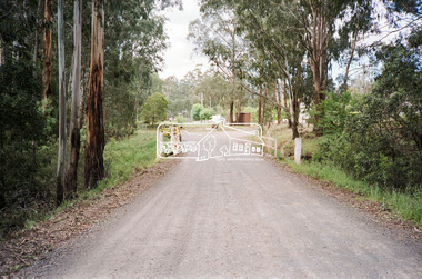
Negative - Photograph, Cottlesbridge-Strathewen Road, Strathewen, c.Nov. 1987
... school ridge road... cottlesbridge-strathewen road culvert infrastructure roads school ridge ...Photos taken during a review of road and bridge/culvert condition by Eltham Shire Council engineers. A number of the trees were badly burnt or destroyed in the Black Saturday bushfire, 7 Feb. 2009 but some remained standing and identifiable as of 2014 (Google Streetview).Roll of 35mm colour negative film, 4 stripsKodak GB 200 5096bridge, chads creek, chads creek road, cottlesbridge-strathewen road, culvert, infrastructure, roads, school ridge road, strathewen -
 Eltham District Historical Society Inc
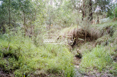
Negative - Photograph, Cottlesbridge-Strathewen Road, Strathewen, c.Nov. 1987
... school ridge road... cottlesbridge-strathewen road culvert infrastructure roads school ridge ...Photos taken during a review of road and bridge/culvert condition by Eltham Shire Council engineers. A number of the trees were badly burnt or destroyed in the Black Saturday bushfire, 7 Feb. 2009 but some remained standing and identifiable as of 2014 (Google Streetview).Roll of 35mm colour negative film, 4 stripsKodak GB 200 5096bridge, chads creek, chads creek road, cottlesbridge-strathewen road, culvert, infrastructure, roads, school ridge road, strathewen -
 Eltham District Historical Society Inc
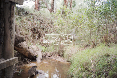
Negative - Photograph, Cottlesbridge-Strathewen Road, Strathewen, c.Nov. 1987
... school ridge road... cottlesbridge-strathewen road culvert infrastructure roads school ridge ...Photos taken during a review of road and bridge/culvert condition by Eltham Shire Council engineers. A number of the trees were badly burnt or destroyed in the Black Saturday bushfire, 7 Feb. 2009 but some remained standing and identifiable as of 2014 (Google Streetview).Roll of 35mm colour negative film, 4 stripsKodak GB 200 5096bridge, chads creek, chads creek road, cottlesbridge-strathewen road, culvert, infrastructure, roads, school ridge road, strathewen -
 Eltham District Historical Society Inc
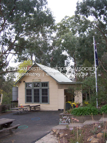
Photograph - Digital Photograph, Marguerite Marshall, Strathewen Primary School, 20 August 2008
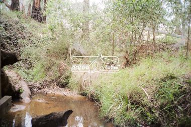
... to build he Strathewen State School on School Ridge Road... Ridge Road, Strathewen. Residents and the Education Department ...The school building originally owned by locals was lost in the Black Saturday 2009 bushfires. Land was purchased in 1914 to build he Strathewen State School on School Ridge Road, Strathewen. Residents and the Education Department contributed funds for the building which the Education Department then leased for a small annual fee. The school opened with one teacher in 1917 with no equipment. In 1921 the Education Department provided desks and a hexagonal shelter shed and took control in 1925. After this photo was taken, the school was destroyed in Black Saturday on 9 February 2009. Published: Nillumbik Now and Then / Marguerite Marshall 2008; photographs Alan King with Marguerite Marshall.; p89This collection of almost 130 photos about places and people within the Shire of Nillumbik, an urban and rural municipality in Melbourne's north, contributes to an understanding of the history of the Shire. Published in 2008 immediately prior to the Black Saturday bushfires of February 7, 2009, it documents sites that were impacted, and in some cases destroyed by the fires. It includes photographs taken especially for the publication, creating a unique time capsule representing the Shire in the early 21st century. It remains the most recent comprehenesive publication devoted to the Shire's history connecting local residents to the past. nillumbik now and then (marshall-king) collection, strathewen primary school -
 Cobram Historical Society Inc
Hand flueter base
Used to iron lace cuffs and collarsRidged base.C.W. Whitfeild. Syracuse.N.Y.pat.app'd for -
 Mt Dandenong & District Historical Society Inc.
Photograph
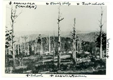
Iconic photograph taken by Edgar Dower on Ridge Road in 1913 from an area known as Point Clear that shows the buildings of early Mt Dandenong before the CRB road went through in the 1920s.Black and white photograph with tall, dead trees in foreground and a view of hills in the distance. Buildings can be seen across the centre of the photograph. There are handwritten annotations around the border with arrows referring to areas in the photograph. Reverse of photograph has handwritten description by John Lundy-Clarke.Front from top left: Namoora (Lumeah), Dower's Shop, First school, Talent's, Langford's house, School. Reverse: 1913 view from O'Halloran's LOT 4, Section 3 on Ridge Road. Showing Lumeah (Namoora) Farndons Road (fence) School, Lowes House?, Falls Road Shop (Dowers) Langford's Falls Road (LOT 9, Section 1) Shed on Colomb's LOT 19, Sect 2 Colomb's House (Fergusons) First school Campbell's Blythes Road Lil Badenhop's P.O. In middle distance - Talent's homestead and sheds.point clear, namoora, lumeah, langford, dower, talent, colomb, ferguson, campbell, farndons road, mt dandenong school -
 Eltham District Historical Society Inc
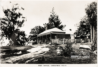
Photograph, Post Office, Christmas Hills
The site of the Post office was the south side of Eltham on the Yarra Glen road. 0.3 km SW of Ridge Rd., now freehold. The first Post Office-cum General Store at Christmas Hills was built by Thomas Young during the 1870s, when the district was a thriving farming community. Young operated postal services here from 1874 to 1909. Moreover, the two front rooms of this general store aslo served as the district's first school. When the store was demolished in the early 1900s, these school-rooms were moved to the residence next door (to the east) which took over the role of the Post Office store until the service finally closed in the early 1970s. The latter building is still in use today as a private residence". Christmas Hills Past & Present (Yarra Glen & District Historical Society, 2004)Roll of medium format 120 6x6 black and white negative film, 4 framesAgfa APX 100shire of eltham pioneers photograph collection, sepp, christmas hills, post office -
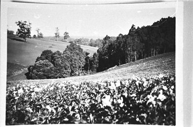 Southern Sherbrooke Historical Society Inc.
Photograph - Madigan potato crop looking east from School Road toward Menzies Creek station
Photo of the Madigan potato crop in a paddock below their home. The photo is taken from School Rd, looking east across the valley in the direction of Menzies Creek station. On the left is the ridge where Black Hill Rd is and on the right the ground slopes up towards the school after School Rd makes a right-angled turn. Beyond the peas are a cluster of trees, the lowest of which are blue gums.